Coastal Erosion & Monitoring

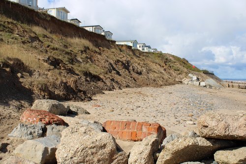
Coastal erosion is a major issue affecting coastlines all around the world. It is caused by a variety of factors, including sea level rise, storm surge, and wave action. Coastal erosion can have severe consequences, including damage to infrastructure, loss of property, and the destruction of habitats. Monitoring coastal erosion is therefore a crucial task for coastal managers and engineers. The use of drones for coastal erosion monitoring has become increasingly popular in recent years, offering several advantages over traditional methods. In this case study, we will explore the use of drones for coastal erosion monitoring and how PB Aerial Imaging Ltd can solve your problem.

The Problem

Coastal erosion is a significant problem for many coastal communities, and monitoring the erosion rates is crucial for coastal managers and engineers. Traditional methods of monitoring coastal erosion can be time-consuming, expensive, and may not provide the level of detail required for accurate assessments. Ground-based measurements can be limited in terms of coverage and accuracy, while satellite-based measurements can be expensive and may not provide the resolution required for detailed assessments. As a result, many coastal managers and engineers are turning to drones for coastal erosion monitoring.

The Solution

Drones offer several advantages over traditional methods of coastal erosion monitoring. They can provide high-resolution imagery and data that can be used to assess the rate and extent of coastal erosion. Drones can cover large areas quickly and provide data in real-time, allowing coastal managers and engineers to make informed decisions quickly.

PB Aerial Imaging Ltd offers a range of drone-based solutions for coastal erosion monitoring. Our drones are equipped with high-resolution cameras and sensors that can capture detailed images and data of coastal areas. We can provide a range of services, including:

  1. Aerial Photography and Videography

    We can capture high-resolution aerial images and videos of coastal areas, providing a comprehensive view of the coastline. Our drones can fly at various altitudes, allowing us to capture images and videos from different perspectives.

  2. Surveying and Mapping

    Our drones can be used to create accurate 3D maps of coastal areas, providing detailed information about the topography and elevation of the coastline. This data can be used to monitor changes in the coastline over time and identify areas of erosion.

  3. Real-Time Monitoring

    Our drones can provide real-time monitoring of coastal areas, allowing us to detect changes in the coastline as they happen. This can be useful for detecting areas of erosion and assessing the effectiveness of coastal protection measures.

  4. Thermal Imaging

    We can use thermal imaging to detect areas of erosion and assess the temperature of the water and land. This information can be used to identify areas of erosion and assess the effectiveness of coastal protection measures.

Case Study: Coastal Erosion Monitoring in Cornwall

PB Aerial Imaging Ltd was recently hired to monitor coastal erosion in Cornwall, UK. The client was a local council responsible for managing the coastline in the area. The council was concerned about the rate of coastal erosion and wanted to monitor the coastline to assess the extent of the problem.

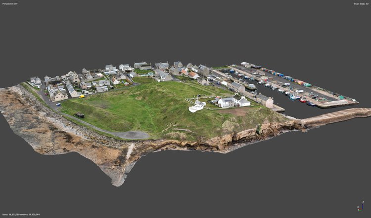
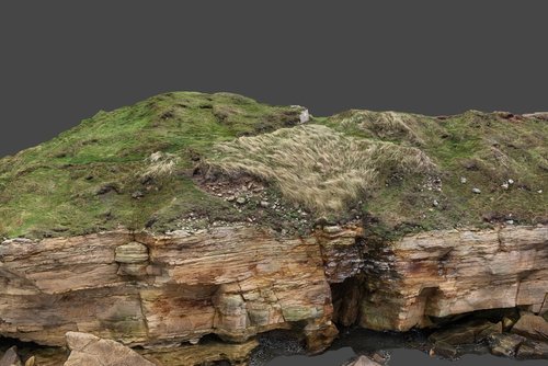
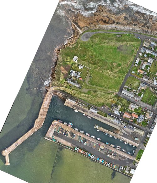
We began by conducting a site survey to assess the area and identify any potential hazards. We then planned a series of drone flights to cover the entire coastline. We used high-resolution cameras and sensors to capture detailed images and data of the coastline. The data was processed and analysed to create accurate 3D maps of the coastline.

We provided the council with regular reports on the extent of coastal erosion and identified areas of concern. The council was able to use this information to assess the effectiveness of coastal protection measures and plan future interventions.

Conclusion

The use of drones for coastal erosion monitoring offers several advantages over traditional methods. Drones can provide high-resolution imagery and data that can be used to assess the rate and extent of coastal erosion. They can cover large areas quickly and provide data in real-time, allowing coastal managers and engineers to make timely and accurate decisions. PB Aerial Imaging have the equipment, knowledge and experience to tackle your survey needs


We’d love to work with you